Places Named in British Periodical Writing on the Levant, 1750–1829
 View full map
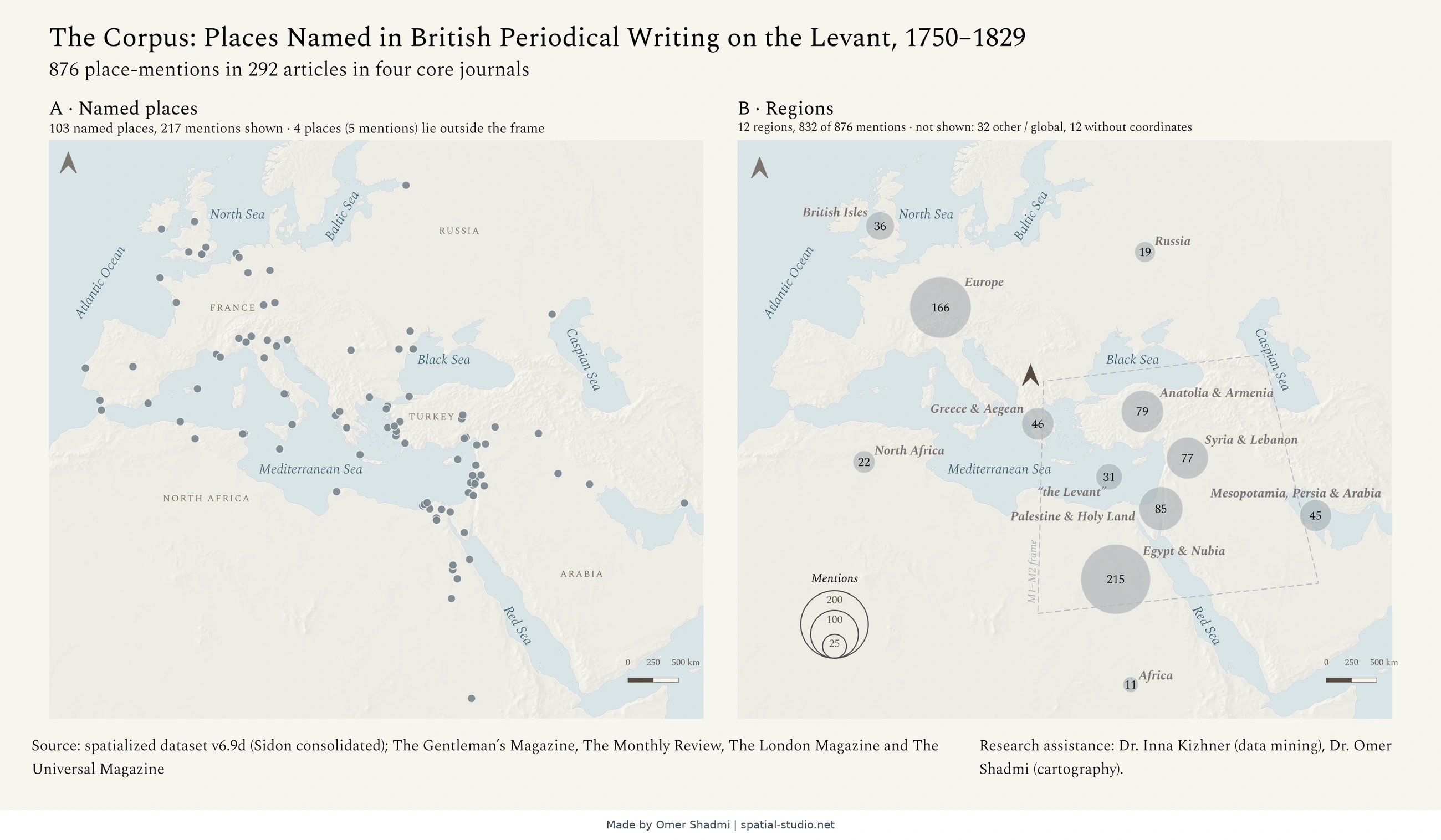
This map shows the places that British periodicals wrote about when they covered the Levant, the eastern shore of the Mediterranean, between 1750 and 1829. Panel A marks every named place with a dot. Panel B groups the mentions by region: the bigger the circle, the more often the region was mentioned. Together, the panels show where British writers looked.
How this map was created
Places Named in British Periodical Writing on the Levant, 1750–1829
The Spatial Studio – Omer Shadmi · spatial-studio.net
This file was created in retrospect using documentation of the workflow
General information
This map shows the places that British periodicals wrote about when they covered the Levant, the eastern shore of the Mediterranean, between 1750 and 1829. Panel A marks every named place with a dot. Panel B groups the mentions by region: the bigger the circle, the more often the region was mentioned. Together, the panels show where British writers looked.
Map title | Places Named in British Periodical Writing on the Levant, 1750–1829 |
Author | Omer Shadmi |
Owner | Zoe Beenstock |
Publication date / version | Version 1 (publication date to be added) |
Geographic coverage | Europe, the Mediterranean and the Near East: from the British Isles and the Baltic Sea to the Caspian Sea, Arabia and North Africa |
CRS | Lambert azimuthal equal-area, centred on 38°N, 25°E (+proj=laea +lat_0=38 +lon_0=25 +x_0=0 +y_0=0 +datum=WGS84 +units=m); no EPSG code |
Dimensions | Two panels of 102.5 × 90.6 mm each |
Map file | Zoe m0.png |
Software | QGIS 3.34 and 3.40; Claude (Anthropic); Kepler.gl (data exploration) |
Documentation date / method | 29 October 2026. Written in retrospect from the project files and the records of the Claude conversations. Documented by The Spatial Studio (spatial-studio.net) |
Permanent link | https://spatial-studio.net/maps/british-periodicals-places/ |
Suggested citation
Please consult the owner, Zoe Beenstock, for how to cite this map.
How this map was created
Stage | What was done | AI / Human |
1. | Dataset of mentions of the Levant in a list of British periodicals by keywords | Human (Inna Kizhner) |
2. | Creating a spatialized dataset of places included in the original dataset: geocoding the database by automated reconciliation with Wikidata and other datasets with constant review and decisions making about what places to include, right reconciliation, and right names to use. | Human (Omer Shadmi, Zoe Beenstock) |
3. | Visualizing the spatialized database using Kepler.gl | Human (Omer Shadmi) |
4. | Exploring insights in the visualization | Human (Zoe and Omer) |
5. | An AI agent created by Zoe to search for insights in Kepler. | AI (Claude) |
6. | Exploration of important insights using Claude and in dialogue with Omer. Three different maps were chosen for production | Humans (Zoe) |
7. | Creation of map drafts by Zoe’s Claude | AI (Claude) |
8 | Omer sent Zoe a prompt to produce a QGIS project he can design. | Human (Omer) |
9 | Zoe’s Claude produced a QGIS project | AI (Claude) |
10 | Review of the AI-generated QGIS project for CRS, locations, layers sources, labels, and data | Human |
11 | Initial design rounds using a Claude skill Omer created: options for the basemap (colour, relief, sea texture), fonts and symbols, shown on all three maps, while the data is locked. After each round Omer chose and refined the options. | AI (Claude) generates options; Human (Omer) selects |
12 | Change of CRS from an equirectangular projection (true scale at 40°N) to a Lambert azimuthal equal-area projection centred on 38°N, 25°E. Claude proposed it and rendered both versions for comparison; Omer chose it. | AI (Claude) proposes and renders; Human (Omer) decides |
13 | Further design rounds on basemap colour, symbols (rings for places, full circles for the M0b regions) and labels. Omer asked for a calmer, lighter look: sea ripples removed, thinner coastlines, quieter labels. | AI (Claude) generates options; Human (Omer) selects and gives feedback |
14 | Layout: a QGIS project with a 16:9 slide layout for the M0 diptych, with scale bar and north arrow. Label colours, sizes, legend and label positions were then adjusted in QGIS. | AI (Claude) builds the project; Human (Omer) adjusts in QGIS. |
15 | Writing a style guide for the series (labels, colours, typography, slide grid, CRS) from the saved M0 project, to reuse for M1 and M2. | AI (Claude), at Omer's request |
16 | Check of data and font licenses. | AI (Claude) |
17 | Several rounds of changing minor issues | AI and Human (Zoe and Omer) |
18 | Final Human review by a premade map publication check list | Human (Omer) |
Data sources
Data | Source |
Places and other data | Researcher’s dataset of place-mentions in four British periodicals, 1750–1829: The Gentleman’s Magazine, The Monthly Review, The London Magazine and The Universal Magazine. Data mining: Dr. Inna Kizhner. |
Land and sea polygons | Natural Earth 1:50m (public domain) |
License
This map belongs to Zoe Beenstock. Any use of it requires her approval. Requests can be made through The Spatial Studio (spatial-studio.net).
Version history
Version 1: first version of the map (date to be added).
Cite this map
Shadmi, Omer. (n.d.). Places Named in British Periodical Writing on the Levant, 1750–1829 [Map]. The Spatial Studio. https://spatial-studio.net/maps/british-periodicals-places/
The documentation requests consultation with Zoe Beenstock about citation and permission to use the map. This reference identifies the displayed map; it does not grant permission to reuse it.
License
This map belongs to Zoe Beenstock. Any use of it requires her approval. Requests can be made through The Spatial Studio (spatial-studio.net).
Permanent link: https://spatial-studio.net/maps/british-periodicals-places/