The 50sqkm Atlas: Map 1 Topography
 View full map
This is map is the first map of the 50sqkm atlas,
How this map was created
Topography (Map 01, The 50sqkm Atlas)
The Spatial Studio – Omer Shadmi · spatial-studio.net
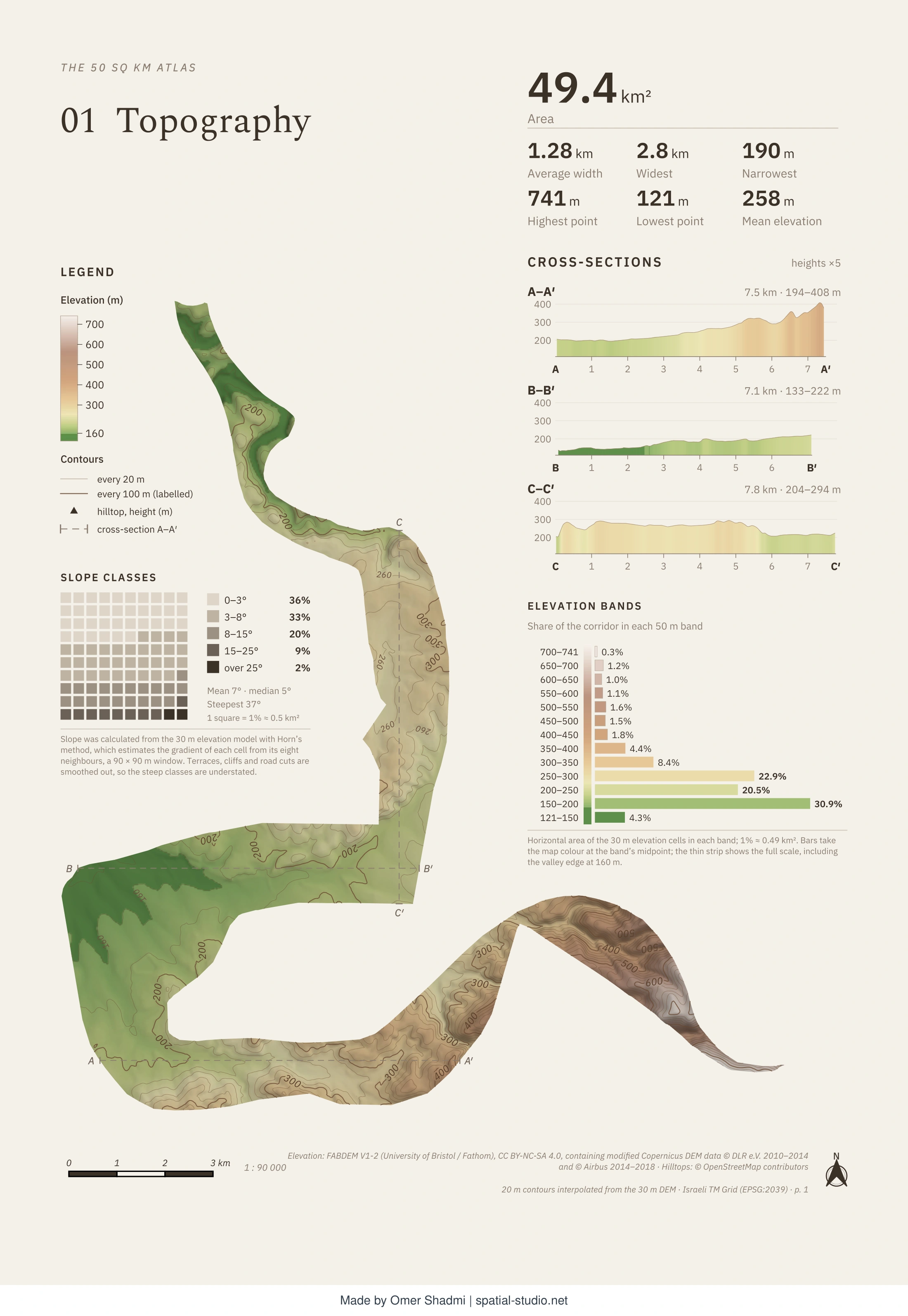
This is the first map of the 50sqkm atlas, a project aiming to study a specific area of unique geopolitical significance through cartography. The first map shows the area’s most basic conditions – it’s topography. The area is a narrow corridor whose general direction is north south. Mostly hilly – except for the edge of a wide valley at its central part. Historically, the terrain and slopes make the area not ideal for human settlement due to difficult access, especially in the southern part that rises to above 700 meters above sea level in steep slopes. On the other hand, the valley allowed the cultivation of grains, the basis of the local diet, and the hills are suitable for the cultivation of vines and olives. The valley separates the two hilly areas and allows movement of animals, people, and vegetation in an east west direction.
General information
This is map is the first map of the 50sqkm atlas,
Map title | Topography (Map 01 of The 50 sq km Atlas) |
Author | Omer Shadmi |
Owner | Omer Shadmi |
Publication date / version | Version 1 |
CRS | EPSG:2039, Israel 1993 / Israeli TM Grid. |
Dimensions | A4 portrait page. Map frame 177.5 × 198.7 mm at a fixed scale of 1:85,000 |
Map file | Layout “Map 01 — Topography (A4)” in aoi_topography.qgz (exported file name to be added) |
Software | QGIS (project, layout and styles, built with PyQGIS);; Claude (Anthropic) |
Documentation date / method | 29 October 2026. Written in retrospect from the project files and the records of the Claude conversations. Documented by The Spatial Studio (spatial-studio.net) |
Permanent link | https://spatial-studio.net/maps/50sqkm-topography/ |
Suggested citation
Shadmi, O. (2026). Topography [Map 01 of The 50 sq km Atlas]. Version 1. The Spatial Studio, spatial-studio.net.
How this map was created
Stage | What was done | AI / Human |
1. | Defining the project: a digital atlas of one corridor-shaped area of interest (the AOI, drawn as a polygon of 49.4 km²), in which every map looks at a different aspect of the place. Topography was chosen as the first map, and it sets the page, frame, fonts and colours for the whole atlas. The map should be beautiful at first sight and rewarding to read closely. | Human (Omer Shadmi) |
2. | Data acquisition with a Claude skill. Claude read the AOI polygon and fetched the FABDEM V1-2 elevation model. | AI (Claude) runs the workflow; Human (Omer) defines the AOI and the theme |
3. | Contours at 5, 10, 20, 30 and 50 m were traced from the same DEM with GDAL and clipped to the AOI polygon, with no smoothing. Everything was packaged as a GeoPackage, a cloud-optimised GeoTIFF with metadata, a QGIS project, style files and a manifest and README recording sources, licence and processing history. | AI (Claude) |
4. | Design rounds using a designated skill built by Omer. Claude showed several options; Omer chose and refined them while data is locked. | AI (Claude) generates options; Human (Omer) selects and gives feedback |
5. | Hilltops. Omer wanted surveyed heights, not heights calculated from the DEM, so the DEM-derived hilltops were rejected. Claude searched possible sources (data.gov.il, GovMap, OpenStreetMap); OpenStreetMap was found too sparse and the open portals held no elevation data. Omer supplied a layer of 36 hilltop points with heights from the Israel 1:50,000 topographic map. Claude styled it as small triangles with height labels and compared the heights with the DEM. | Human (Omer) obtains the data; AI (Claude) styles and checks |
6. | Edge of the corridor. The AOI edge looked jagged because the DEM cells are 30 m wide. Claude made a display copy of the DEM that keeps the cells touching the AOI edge, and an “edge mask” layer that cuts the picture exactly along the AOI line. Statistics are still taken from the original DEM. | AI (Claude); Human (Omer) approves |
7. | Information boxes, one at a time. Omer decided what each box contains. Claude drew each as a PNG for approval and made the SVG only after approval: key figures, slope classes (calculated from FABDEM with Horn’s method, shown as a 10 × 10 grid where one square is 1%), elevation bands, three cross-sections (A–A′, B–B′, C–C′, heights ×5, drawn in the colours of the map) and a legend. Cross-section lines went through several rounds until a thin, light line was approved. | AI (Claude) designs; Human (Omer) approves or revises each box |
8. | Checking the numbers against the data. The slope, elevation-band and profile figures were recalculated from the original DEM. Two honesty points were settled: band labels show the real range (121–741 m, not rounded values), and the 741 m high point lies on the AOI edge, so it is never labelled as a summit. One hilltop (291 m) differs from the DEM by 14 m and was flagged for checking against the 1:50,000 map. Spring data from the Israel Water Authority were also tried for the atlas and rejected as inaccurate. | AI (Claude) checks; Human (Omer) decides |
9. | Page layout. Claude built an A4 portrait layout in QGIS: title block, the map at 1:85,000 in a centred frame, boxes around the corridor, legend, scale bar, north arrow and a footer with sources. Omer removed the line under the title, moved the scale from 1:90,000 to 1:85,000, and removed OpenStreetMap data and its credit from the map. | AI (Claude) builds; Human (Omer) decides |
10. | Smaller fixes, offered as a list of tweaks. Omer answered each item with 1 (Claude does it), 2 (leave it) or 3 (Omer does it, with instructions). Examples: contour labels moved away from hilltops and from the AOI edge, gaps cut in contour lines under labels. | AI and Human (Omer) |
11. | Documentation for reuse. At Omer’s request Claude wrote an atlas style guide and a style card for Map 01, so the next maps follow the same system, and packaged the updated project as a one-step installation zip with relative paths. | AI (Claude), at Omer’s request |
12. | Final human review before publication (several minor changes done in QGIS) | Human (Omer) |
Data sources
Data | Source |
Elevation (DEM) | FABDEM V1-2, a 30 m bare-earth elevation model made from the Copernicus GLO-30 model with buildings and forests removed. Hawker, L., Uhe, P., Paulo, L., Sosa, J., Savage, J., Sampson, C., Neal, J. (2022), Environmental Research Letters 17, 024016. University of Bristol / Fathom. Tiles N31E034 and N31E035. CC BY-NC-SA 4.0. Contains modified Copernicus DEM data © DLR e.V. 2010–2014 and © Airbus 2014–2018. https://doi.org/10.5523/bris.s5hqmjcdj8yo2ibzi9b4ew3sn |
Contours, hillshade, slope, elevation bands, cross-section profiles, key figures | Calculated for this map from FABDEM V1-2 (contours with GDAL; slope with Horn’s method on a 90 × 90 m window). The 5 m and 10 m contours are interpolated from a 30 m grid, so they are a cartographic representation, not survey-grade. |
Hilltops | 36 points with heights from the Israel 1:50,000 topographic map (Survey of Israel, viewed through the Amud Anan basemap), supplied by the author. Terms of use and credit still to be confirmed. |
Fonts | Spectral (titles) and IBM Plex Sans (all other text), both open-source fonts under the SIL Open Font License. |
License
Anyone may use, copy and share this map for non-commercial purposes, as long as they cite it properly. Adaptations must be shared under the same terms (CC BY-NC-SA 4.0), because the map is based on FABDEM elevation data. For other uses, please contact The Spatial Studio (spatial-studio.net).
Version history
None.
Cite this map
Shadmi, Omer. (2026). The 50sqkm Atlas: Map 1 Topography [Map]. The Spatial Studio. https://spatial-studio.net/maps/50sqkm-topography/
License
Anyone may use, copy and share this map for non-commercial purposes, as long as they cite it properly. Adaptations must be shared under the same terms (CC BY-NC-SA 4.0), because the map is based on FABDEM elevation data. For other uses, please contact The Spatial Studio (spatial-studio.net).
Permanent link: https://spatial-studio.net/maps/50sqkm-topography/